Risk assessing functional sites with Addresscloud
4 Minute ReadAddresscloud customers can perform lightning fast risk assessments at address level, but what if the risk spans a whole site? Today we launch our new custom areas tool backed by a new API endpoint which allows our users to assess any shape for flood, subsidence and crime in less than a second. This new tool is made possible thanks to the excellent work that Tomas recently wrote about. This is what it looks like in action:
What problem does it solve?
The best way to explain this is with an example. As a child I used to get pretty excited if I came out of school on Friday to see my folks there with the caravan hooked up to the car. We would be whisked off to the exotic north Kent coast for a weekend of fun on the beach (or if we were unlucky playing cards listening to the rain hammer down!). Evenings would be spent in the campsite bingo hall with the other campers and the substantial community of elderly residents, many of whom lived semi-permanently in park homes.
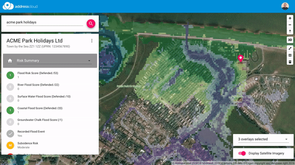
The close proximity to the sea is clearly the major selling point for us holidaymakers and the retirees but what does this look like from an insurer's perspective? The map below shows the location and associated risk assessment through Addresscloud using flood data provided by our partner JBA Risk Management. Background map tiles are provided by the Ordnance Survey via their excellent free Open Zoomstack product. The location and organisation name have been anonymised:

Based on this assessment the risk looks quite attractive. However, the point is sitting on the reception (and bingo hall!). Whilst OS maps are very comprehensive only permanent structures are mapped, therefore excluding the park homes which often have no formal address. Let's zoom out a little and take a look at the satellite imagery and toggle on the flood layers to give us some additional context:

The picture doesn't look quite so rosy for the whole site! At this point we could move the pin around the map to perform individual point based assessments but what would be really useful would be a site level assessment, enter the custom area tool! Using the new tool, the little polygon icon below on the right, users can now draw a custom area very quickly for any shape. Once the shape is complete the system quickly calculates a site level assessment, in this case giving us a worst case risk assessment:

Based on this information we may choose to decline cover or apply additional terms. Here we have opted for a worst case risk assessment but since different insurers have different risk appetites Addresscloud is fully configurable to provide best, worst or average assessments.
In Summary
The new custom area tool allows us to move beyond the point to quickly assess functional sites. Here we have worked through an example of a caravan site with park homes but the same concept could be extended to any large site: farms, hospitals, schools and industrial estates to name but a few. Addresscloud allows customers to tailor the result to their specific risk appetite through simple configuration.
If you are interested in seeing how Addresscloud can help your organisation why not get in touch.
Addresscloud in Action
See how Addresscloud services are helping our customers solve real-world challenges.